Analysis
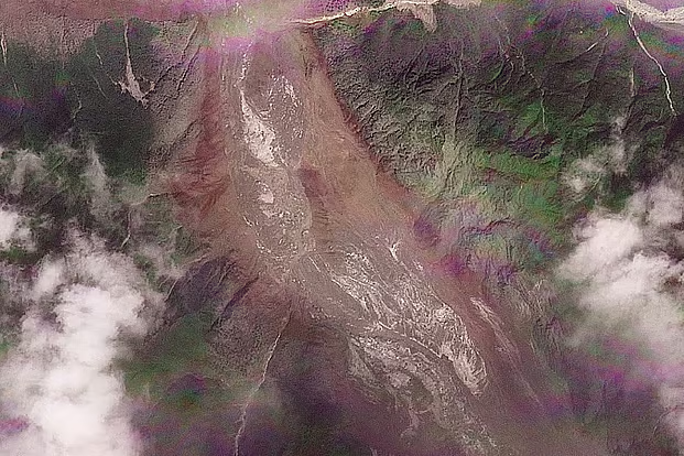
Around 9 a.m. last Wednesday, a devastating torrent of water surged out of the Bhotekoshi River in Nepal’s Rasuwa district, tearing through areas along the Tibet-China border before flowing downstream into the Trishuli River. The landslide and flash flood have so far been confirmed to have killed 472 people across Nepal and Tibet. Nearly 1,500 people remain missing, more than 800 of them foreign tourists.
According to Nepal’s disaster management agencies, this is the second major destructive flood in the 30-kilometer river basin stretching from Bhotekoshi to Trishuli in the past 13 months. Given its geography and geology, Nepal is one of the world’s most disaster-prone regions, and this flood is yet another proof of that.
This was not, in fact, simply a weather-driven natural disaster. Two important factors were at work behind it. On one hand, rising Himalayan temperatures driven by global warming are causing glaciers to melt, accumulating large amounts of water in various fragile locations. On the other hand, the ongoing collision of the Indian and Eurasian tectonic plates continues to shift and reshape the Himalayan mountains.
What actually happened
Three main explanations have emerged so far for this devastating disaster, though all trace back to the same underlying cause.
Nepal’s Foreign Minister Shishir Khanal told parliament that at 8:37 a.m. local time last Wednesday, an earthquake triggered a massive landslide that completely blocked the river’s course. The resulting pressure of water eventually broke through that natural dam, unleashing the disaster.
The U.S. Geological Survey (USGS) recorded a magnitude-4.4 tremor around that time, roughly 47 kilometers north of Gosaikunda in Tibet. It later clarified that this was not an actual earthquake, but a tremor generated by the massive landslide itself.
Another explanation from scientists points in largely the same direction. Shashwat Sanyal, a scientist at the International Centre for Integrated Mountain Development (ICIMOD), told CNN that the devastating flood originated in the Lende Khola, a tributary of the Bhotekoshi. A massive collapse of ice and rock from a glacier temporarily blocked the river’s course. Water pressure later broke through it, unleashing a massive surge that turned into the flash flood.
Rizan Bhakta Kayastha, head of the Department of Environmental Science at Kathmandu University and a glacier expert, has offered a similar assessment after discussions with Nepali and Chinese scientists. He said the Lende Khola’s course was blocked in exactly the same way last year too, causing a flood.
Satellite images from August 24 are being reviewed to determine whether any unusual change occurred in the water flow of the glacial region upstream of the river. Analysis of before-and-after images shows sudden, large surges forming there.
All three explanations point to the same underlying story: a Himalayan mountain river’s course was blocked for some reason, and the massive volume of water that built up eventually burst forth catastrophically.
The most devastating scene from this disaster was at the Rasuwagadhi crossing on the China-Nepal border, where the main bridge leading to the border gate was completely swept away by the floodwaters. Many deaths are feared there. This region has witnessed similar major natural disasters more than once before.
The same story for hundreds of years
This is not the first time a glacial lake outburst flood, or an inland tsunami, has struck this part of the Himalayas. Nepal has witnessed many such devastating disasters over hundreds of years. According to a recent study by the regional research organization ICIMOD, the rate of glacial ice melt in the Hindu Kush Himalaya region has nearly doubled since 2000. As a result, roughly 2 million people living downstream of these glaciers and their river basins are now at extreme risk.
A similar flood occurred last year too, from a glacial lake outburst upstream in Tibet. But even before that, in July 1981, a glacial lake in Tibet’s Zhangzangbo valley suddenly burst. A subsequent World Bank review said the cause of that flood was unknown at the time; a study by Chinese scientists years later clarified the cause.
According to that study, published in the journals Nature and Scientific Reports, the 1981 flood killed more than 200 people, destroyed the Friendship Bridge, and severely damaged the Sun Koshi hydropower station. The same underlying cause was found behind major floods in 1964 and 1983 as well.
Nepal’s history of such disasters goes back even further. According to World Bank estimates, the country has experienced a total of 24 major floods from glacial lake outbursts, 14 originating in Nepal and 10 in Tibet.
Historical records show that roughly 450 years ago, the natural dam of a lake at Machhapuchhre in the Seti Khola river basin in Nepal collapsed. That collapse, combined with a mountain torrent, sent tens of millions of tons of mud and rock crashing down, burying the Pokhara valley under debris roughly 50 to 60 meters deep.
Analysts at the Washington-based Stimson Center have also identified the specific cause of last year’s flood at this exact point on the Nepal-China border. According to their review, that flood, which struck on July 8, 2025, was caused by the sudden collapse of the natural dam of a glacial lake located roughly 35 kilometers upstream from the border, at an elevation of 5,150 meters.
Water pooling upstream
Hundreds of such lakes are constantly forming across the Himalayas as glaciers melt. This enormous volume of water, pooled from melting ice high in the mountains, is like so many time bombs — extremely dangerous and high-risk.
According to a 2020 survey by the United Nations Development Programme (UNDP), there are a total of 3,624 glacial lakes across the Koshi, Gandaki and Karnali river basins, of which 47 were identified as “extremely high risk.” Of these, 25 are in Tibet, 21 in Nepal and 1 in India.
But such lists cannot always predict an impending disaster. These temporary lakes, formed on the surface of melting glaciers, can grow dramatically in size within just a few months and then suddenly burst. As a result, a compiled list can become outdated or irrelevant before it is even published. For instance, the lake responsible for the catastrophic 2025 flood was not even on scientists’ lists before the disaster.
Did China warn Nepal?
The same question keeps resurfacing after every catastrophic flood in the Himalayan region: Why doesn’t Nepal get advance warning of these disasters?
After the July 2025 disaster, the director general of Nepal’s climate and meteorology department made clear that Nepal has no effective bilateral mechanism to receive climate or glacier-related data from the Tibet region. China occasionally issues advance warnings for heavy rainfall, but a glacial lake outburst does not depend on rainfall alone.
Nepali officials say that during last year’s flash flood, too, they received no warning from any weather or scientific forecasting center. They first learned the floodwater had entered Nepal only about an hour before it arrived — and even then, not from any forecasting agency, but from security personnel stationed at the border.
After that devastating flood last year, the Nepali government decided to work jointly with China to strengthen early-warning systems. To help address this growing risk, the United Nations’ Green Climate Fund approved a grant of roughly $36 million in July 2025.
But despite these efforts, no automated system capable of issuing real-time warnings across the border has yet been built. This week’s disaster in Nepal is the clearest proof of that.
River-bank settlements suffered the worst damage from the surging water, with entire villages swept away in many places.
Tectonic collision, a permanent crisis
Melting glacial ice, bursting lakes, and the lack of an early-warning system may seem like temporary crises for Nepal. But beyond these, the country has a geographic and structural vulnerability that is entirely permanent.
Geographically, Nepal sits directly atop the extreme collision zone of the Indian and Eurasian tectonic plates. These two massive plates are colliding into one another at a rate of roughly 20 to 21 millimeters per year.
Roughly 50 million years ago, the head-on collision of these two plates caused the ancient Tethys Ocean to disappear entirely — and from that collision, the Himalayan mountain range was born. At that time, the Earth’s crust folded upward with immense force, creating this vast mountain range and its highest peaks.
Geologists say the collision that began tens of millions of years ago has still not stopped. It continues today, albeit extremely slowly. Because of this active geological process, the Himalayas are considered the world’s youngest and fastest-growing mountain range.
Because of this constant collision, the Himalayan range is still rising by an average of roughly 5 millimeters every year. And it is this permanent geological transformation that repeatedly exposes Nepal to devastating earthquakes and landslides.
Nepal no longer needs a major earthquake to trigger floods or landslides — a moderate or even mild tremor is enough. Major disasters like the catastrophic 2015 earthquake have already left the mountain slopes in this region loose and fragile. As a result, even a slight shake is now enough to trigger the collapse of that loosened soil and rock.
Last Wednesday’s disaster is the latest example of this. Even though no actual earthquake occurred that day, the internal tremor caused by a major landslide alone was enough to bring down an entire mountain slope. The mud and rock from that collapse completely blocked the river’s course, which later turned into the catastrophic flash flood.
Nepal’s capital, Kathmandu, lies just south of this border mountain region. Last Wednesday’s floodwaters, along with tens of millions of tons of mud and rock swept down from the mountains, surged down the river valley toward settlements like Bidur, located roughly 50 kilometers northwest of Kathmandu.
Unplanned development is also to blame
The final factor behind Nepal’s disaster is the country’s construction practices and infrastructure built in the wrong locations. A 2024 study found that the risk of a glacial lake outburst was completely ignored during construction of the China-Nepal trade corridor and highway. Major land ports and customs offices have been built right along river basins and floodplains.
A joint study by researcher Nitesh Khadka and his team at the Institute of Mountain Hazards and Environment, part of the Chinese Academy of Sciences in Chengdu, found that a glacial lake outburst flood could affect both China and Nepal. It could put at risk roughly 103 kilometers of the China-Nepal highway, 103 bridges, two major land ports, and 3,301 structures across both countries.
That risk has already been borne out in practice. The Timure customs outpost, near the Rasuwagadhi crossing on the Nepal-China border, has been completely destroyed twice in the past 13 months. Last Wednesday’s sudden disaster claimed the lives of many tourists, including pilgrims on the Kailash Mansarovar journey from India.