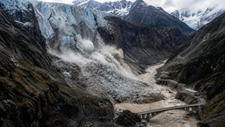
Glaciers, snowpack and mountain terrain across the Himalayan region are growing increasingly unstable under the effects of climate change, and the recent devastating flood on the Nepal-China border has once again shown how a disaster that begins in the mountains can rapidly cross borders and turn into a major regional crisis. Analysts say that underscores the need for faster, more regular sharing of information on glaciers, rivers, weather and potential disasters among neighboring countries.
In an article titled “The Himalayas Are Sending a Warning: Need for Timely Trans-Border Sharing of Environmental Information,” journalist and analyst Raju Koti writes that the Aug. 26 disaster on the Nepal-China border began with the collapse of a glacier and a massive section of rock beneath it. From an altitude of roughly 5,200 meters, a huge mass of ice and rock swept down into the Langde Khola river, sending a torrent of ice, rock, mud and water into the wider Bhote Koshi and Trishuli river systems.
River levels rose by several meters within a short time, and the fast-moving flow of ice, rock, mud and water caused extensive damage to settlements, roads, bridges and hydropower infrastructure. The disaster’s effects also crossed the border into Tibet’s important Gyirong trade and border area — a natural event that began at an altitude of several thousand meters turned into an international disaster within a very short span of time.
Such disasters in the Himalayas cannot simply be viewed as natural events, the article says. Climate change is altering the stability of glaciers, snowpack and mountains. Rising temperatures are weakening ice through melting, thawing permafrost, and increasing pressure as water seeps into cracks in ice — all processes that can raise risk in mountainous areas. But scientists remain cautious about definitively attributing any single glacial collapse to climate change.
Dense population and expanding infrastructure are adding to the risk in the Himalayan region. Road construction, tunneling, mining and hydropower projects that cut into mountainsides are increasing human presence in high-risk terrain. However, there is as yet no evidence that the Aug. 26 glacial collapse was linked to any specific infrastructure project.
The article emphasizes strengthening early-warning systems as the most effective way to address such disasters. Satellites, seismic sensors, drones, river-level gauges and modern computer models can be used to regularly monitor at-risk glaciers, mountain slopes and glacial lakes. Alongside that, systems are needed to rapidly deliver warnings to local populations through mobile alerts, sirens and other means.
Sharing information among border countries is given particular emphasis. Even if a glacier or mountain lies within one country’s territory, the water and debris that flow down from it can reach another country within minutes or hours. That makes it essential to rapidly share data on glacier conditions, weather, river flow and potential landslides with neighboring countries.
The recent Nepal-China situation has again highlighted this need. About three months before the Aug. 26 disaster, in May, Nepali and Chinese officials met to discuss cooperation on monitoring and addressing flood, weather and glacier-related risks. That meeting included discussion of joint initiatives such as compiling an inventory of glacial lakes and identifying at-risk areas.
Questions have been raised, however, over whether adequate information was shared before the disaster. Nepali officials say a lack of sufficient weather-monitoring stations in high mountain areas, along with limits on cross-border data sharing, made early warning difficult. China, for its part, says information was shared between the two countries in a timely manner and that progress was made on cross-border disaster information sharing at the May meeting.
For Nepal, the issue is not just one of disaster management but also of national security and regional diplomacy. Given Nepal’s geographic position between India and China, environmental change in the Himalayas can directly affect the country’s water, electricity, communication, agriculture and economy. At the same time, the river and environmental systems of India, China and Nepal are all interconnected.
The article calls for Himalayan countries to build an effective regional information-sharing system. Regular exchange of satellite monitoring, river data, weather forecasts, glacier movement and early warnings could substantially reduce disaster losses, it argues.
The Himalayas’ recent events are not simply one country’s disaster; they are a warning for the entire region. As the mountain environment changes rapidly under climate change, such events could become even more unpredictable in the future. Alongside rescue efforts after a disaster strikes, identifying risk in advance and building the capacity to rapidly share information across borders is now among the most urgent priorities.