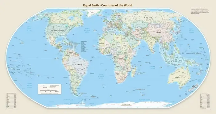
The United Nations General Assembly has voted to adopt a new world map that more accurately depicts the true relative sizes of countries. The vote came Friday after African nations called for correcting a centuries-old distortion. The proposal, called “Correct the Map,” was put forward by African Union member states along with the Bahamas and received overwhelming support. A total of 164 UN member states voted in favor of the proposal, six abstained, and the United States was the only country to vote against it. The news was reported by CNN online.
The proposal aims to present a “fair” depiction of different regions of the world, particularly Africa. It states that the distorted presentation of conventional world maps has made Africa “symbolically smaller” in the collective imagination.
Many world maps today are based on the Mercator projection, introduced by European cartographer Gerardus Mercator in 1569. It has been widely used by sailors because it preserves true directional bearing for north-south lines relative to the equator. But the Mercator projection is less effective as a map of the whole world, because it distorts the size of countries — the farther a country is from the equator, the larger it appears on the map.
Countries closer to the equator, on the other hand, appear comparatively smaller. For example, on the Mercator map, Greenland appears larger than the entire continent of South America and roughly the same size as Africa. In reality, Greenland’s area is roughly equal to that of the Democratic Republic of Congo, while Africa is about 14 times larger than Greenland. Some critics of the Mercator projection believe it remains widely used because it shows Western regions like Europe and North America as comparatively larger and places them at the center of the map. In their view, this can help sustain notions of European superiority.
The UN proposal notes with concern that this distortion has played a role in diminishing people’s perception of the size of Africa, Latin America and South Asia, and in maintaining an unbalanced view of the world. The proposal also states that this distortion can make the socioeconomic realities, infrastructure needs, development potential and prosperity of countries and regions in the Global South seem comparatively smaller to people. At the same time, it can fuel various preconceptions about the environment, geopolitics and security. The UN proposal calls for using the Equal Earth projection instead of the Mercator projection, describing it as a step toward epistemic justice and historical redress. The Equal Earth projection more accurately depicts the true relative sizes of different regions of the world.
The Equal Earth map was introduced at a 2018 conference of the North American Cartographic Information Society. On this map, Europe appears comparatively smaller, Brazil appears larger, and Greenland’s size shrinks dramatically. Africa, meanwhile, appears considerably larger by comparison. French Foreign Minister Jean-Noel Barrot announced Friday that the country would “abandon the Mercator projection” and use a map that more accurately reflects countries’ true sizes. Barrot said the United States, Russia and China visually receive disproportionately more prominence on maps compared with Africa, Latin America or Southeast Asia. He said these distortions gradually become part of people’s perceptions, and that the time has come to correct them.
The initiative gained further momentum at the UN after the African Union adopted the Equal Earth map in March. In April, Togo, on behalf of the African Union, called on UN member states to take the same step. A draft of the proposal was then prepared, and the UN General Assembly held informal discussions on it in July.